Voronoi (Thiessen) Polygon

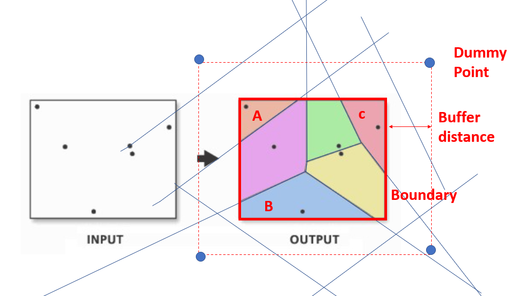
This node creates Voronoi (Thiessen) polygons from the input point data according to the reference boundary. The input data for the reference boundary should be a Polygon or MultiPolygon.

The buffer distance with the provided unit is used to create dummy points that define a virtual boundary around the given reference boundary that controls the output of the Voronoi polygons. If the final Voronoi polygons are smaller than the given reference boundary, you might want to increase the buffer distance. For an illustration of the buffer distance see here.

Options

Point geometry column

Select the geometry column with the points for the Voronoi (Thiessen) polygons.

Boundary geometry column

Select the geometry column with the Polygon or MultiPolygon that defines the reference boundary for the Voronoi (Thiessen) polygons.

Buffer distance

The buffer distance defines the distance of the dummy points that define the virtual boundary from the given reference boundary.

If the buffer distance is too small, the resulting polygons may not fill the entire reference boundary, resulting in gaps or missing parts within it. This is because the buffer distance determines how far away from the reference boundary the Voronoi polygons will be generated, and if the distance is too small, some of the polygons may not intersect with the reference boundary or may only partially intersect with it. For an illustration of the buffer distance see here.

Distance unit

Choose the distance unit to use.

Available options:

  • Use unit from input CRS: Do not re-project but use the unit of the input CRS.
  • Meter: Use the default projection with meter as unit. The projection is the UTM CRS for the UTM zone in which the centroid of the input geometries lies. This projection works well for most latitudes but may not work for some extreme northern locations like Svalbard or far northern Norway in which case you might want to use your own projection prior using this node.
  • Kilometer: Use the default projection with kilometer as unit. The projection is the UTM CRS for the UTM zone in which the centroid of the input geometries lies. This projection works well for most latitudes but may not work for some extreme northern locations like Svalbard or far northern Norway in which case you might want to use your own projection prior using this node.
  • Miles: Use the default projection with miles as unit. The projection is the UTM CRS for the UTM zone in which the centroid of the input geometries lies. This projection works well for most latitudes but may not work for some extreme northern locations like Svalbard or far northern Norway in which case you might want to use your own projection prior using this node.
  • Degree: Use the epsg:4326 with degree as unit.
Keep CRS from input table

If checked the CRS of the input table is retained even if a re-projection was necessary for the selected distance unit.

Input Ports

Icon

Input point data for Voronoi (Thiessen) polygons

Icon

Input boundary data for Voronoi (Thiessen) polygons

Output Ports

Icon

Output table of Voronoi (Thiessen) polygons

Popular Predecessors

  • No recommendations found

Popular Successors

  • No recommendations found

Views

This node has no views

Workflows

  • No workflows found

Links

Developers

You want to see the source code for this node? Click the following button and we’ll use our super-powers to find it for you.